Wild Patagonia – A wilderness expedition through wind, wet and cold

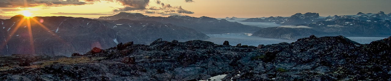
During February and March this year I went to Central Patagonia with my packraft for a 36-day solo wilderness trip in the vicinity of the Northern and Southern Patagonian Ice Fields. I hiked and paddled from Cochrane in the Chilean Aysen Region to El Chalten in Argentina, passing through some areas that seldom see any human visitors. In many areas I planned for several route options depending on both weather and terrain conditions. A part of the trip passed through the dense valdivian rainforest in the fjord landscape close to the Pacific which asked for severe bushwhacking.

I will not write an extensive day by day trip report about this adventure. You can get a sense of the trip by looking at the video and the slideshow. I will just enumerate a series of idiosyncrasies and peculiarities about this adventure in this post.

I arranged two main food resupply points at the start of the trip by sending a food package ahead to the village of Villa O’Higgins with a local bus company. The other package was given to a local Chilean farmer when he passed by Cochrane. I visited his isolated farm near Rio Pascua later during the trip.

To be honest, this trip was not a very enjoyable adventure for me, especially because of often cold, wet and stormy weather and illness at the end. Simply put, it has become the weirdest trip I’ve ever undertaken. The weather during the trip was far from average for the time of the year. It was very wet which was not that unusual though, but it was especially too cold for the austral summer in Patagonia. Temperatures dropped to around freezing on many nights, even at low altitudes and daytime temperatures often barely exceeded +5°c during rainy days. Snow fell down to around 1100-1500m on most days and on a few days even down to 600m. I think the warmest temperature I encountered during the trip must have only been around +15°c on the first two days of the trip and during the last few days. Patagonia is well known for its strong winds and I certainly had my share of it.

This slideshow requires JavaScript.

Because I had planned many crossings over fjords and big lakes with my packraft, the course of the journey was very dependent on wind conditions. I took measures before the trip to be able to plan ahead accordingly. A meteorologist was sending me wind and weather forecasts on my Delorme Inreach SE whenever I asked for it. These messages proved a huge help. Without this help I would probably never have crossed Lago O’Higgins. At the time I had to paddle long distances over the fjords, the weather was by chance always fine though and I even encountered two brief moments with complete windless conditions with the fjords as flat like a mirror.

I didn’t shoot much footage during the bad weather moments and during the harshest bushwhacking and when looking at the video and the pictures, it will probably give an unbalanced impression of how the trip really was. The weather changed completely during the last week of the trip. It became mostly sunny and no rain fell anymore. I became sick and felt weak however during the last week because of all the hardship in the wet and cold earlier during the trip, but I didn’t want to quit the adventure and continued at a slower pace. All this contributed to an almost continuous feeling of disappointment during the trip.

The satisfaction of such an adventure sometimes only appears afterwards when a sense of pride for what you have accomplished starts to predominate. I had a similar experience during my trip on Southern Greenland six years ago, only now this feeling has become much stronger with this adventure. As I said before, this trip through Patagonia has become the weirdest trip I’ve ever done within the meaning of the experience.

I choose to not disclose the exact route travelled and simply notify the bivouac spots on the map. Drawing the exact route followed is an impossible task anyway.

If I would do this trip over again at the same time of the year, I think I wouldn’t change much to my gear list, except perhaps a change from the Inov8 Mudclaw 300 trailrunners to a Rocklite 315 or 295 because of the stiffer sole. The trailrunners were almost new at the start of the trip and were almost worn out at the end. My gear list was not adapted to the coldest conditions encountered. I did not anticipate for such cold conditions deviating so strongly from the long therm average and would have been much more comfortable with warmer clothing in the rain and during the coldest nights. Despite this I think my gear list was perfect for this trip.

Finally I would like to thank the following persons for their additional help before or during the trip: S. Behaeghel, K. Ghijselinck, I. Verelst, M. Perez, L. Schindele & family, Señor H. Guelet & family, Señor R. Flores, M. Salgado. Kudos to all of you!

Bikepacking the roof of Belgium

Three days of splendid weather. What else to do than to try a bikepacking trip over the GR56 trail in the east of Belgium? Up here at this time of the year the valleys of the small peat rivers turn into yellow flower carpets of Daffodils, the perfect time to head to the roof of Belgium.

This trip has been a little experiment for me as after a few multi day bike trips with friends from youth hostel to youth hostel, this was the first time I actually took my camping gear on my bike. As a seasoned lightweight hiker, it was not difficult to fit all the gear in a few bags on the bike, including almost 4 days worth of food. I didn’t find a safe spot on my bike for my camera though and finally took a small backpack along too, just for my camera and tripod. I’m still overthinking how to take fragile electronic equipment like a camera with me on a mountain bike while keeping it easily accessible, so I could leave the backpack behind in the future.

On a late afternoon I put my feet on the pedals, starting from Botrange, the highest point in Belgium. Red flags hung motionless along the nature reserve on this nearly windless day, indicating a prohibition of access because of the fire hazard by the recent drought of this year’s spring. No problem for me as the GR56 trail just swings along the edge of the nature reserve. Some nice single track followed along the Rur river and a steep ascend out of the valley to pass the little village of Monschau on German territory. Up in the Fuhrsbachtal valley I left the GR56 trail behind and biked into the military domain of Elsenborn. Warning signs along the border announced daily shooting exercises between 8AM and 5PM this week. I was safe to enter the military training area now this evening but became a bit worried for tomorrow morning as I had the plan to bivouac in the area. I was a bit upset too as on the website of the Belgian military free access and no single shooting activity at all was announced for this week, once again erroneous information on their website.

The Bieley rock outcrop offered a magnificent view over the Perlenbachtal valley. I made camp in the nearby forest. The next morning a thin layer of fog draped the valley and the Daffodils meadows where wrapped in a layer of frost. While breaking up camp I suddenly heard gun shots in the distance. It was exactly 8AM and the sounds of the shooting continued for at least one hour. Luckily my area was safe and I slowly left the military domain while enjoying the morning sunrays on the yellow flowered banks of the Perlenbach river. Later during the day I biked through the rather desolate Olefbachtal valley, followed by the valley of the Holzwarsche river with the latter definitely being the ice on the cake regarding the wildflowers.

This slideshow requires JavaScript.

A bit too much asphalt to my taste appeared under the tires along the Our river and around Burg-Reuland. I finally found a nice bivouac spot at the edge of a forest about 10km before Sankt-Vith. I felt exhausted that evening after a day biking a distance of 88km through the hilly terrain, especially since this trip was the first time I touched my bike again after my return from Patagonia. Now I could finish the trip tomorrow after 3 days instead of the 4 days I had anticipated for.

The last day offered more pedaling through quiet forests, flowery meadows and some challenging single tracks. Finally I took an alternate route along the nature reserve of Hautes Fagnes where the GR56 follows some hiking trails forbidden for bikers. At the end of the day I returned back to Belgium’s highest point after a first nice bikepacking journey that definitely asks for more.

Club H-A through a snow loaden Hautes Fagnes

Last weekend two groups of forum members from Hiking Advisor went for a snowshoe overnighter through the Belgian Hautes Fagnes. Me and five other enthusiasts chose a longer trip through the unspoilt valley of river Helle and along the burnt trees of Geitzbusch and Noir Flohay which are still standing like ghosts in the fenns after the wildfire of 2011. We broke trail once more along river Statte and had an exciting wild camp in the forest along this little river. The next day we ascended the plateau again through the valley of river Hoegne and searched our way through long lasting snowfall back to our starting point at Centre Nature near Belgians highest point of Signal de Botrange. It had been snowing a lot earlier during the week and snowshoes proved to be indispensable on the higher grounds. There is nothing better than spending the weekend in good company and in a wonderful surrounding to get in shape for my upcoming trip through Patagonia.

This slideshow requires JavaScript.

Packraft sailing the North Sea – Het Zwin to De Panne

Almost 7 o’clock in the morning. The first train of this September Sunday arrives at Knokke station. It’s still dark and night outside. Low drifting grey clouds obscure the rising dawn. I walk to the beach while the latest party goers of the weekend stumble home through the otherwise empty streets of Belgian’s most mundane beach resort. At the beach I walk east and meet the Dutch border after one and a half hour at an emptying river channel. This is were the salt marches of the nature reserve “Het Zwin” make a connection with the North Sea at high tide. Meanwhile the sun has risen and is intermittently piercing through the clouds.

I inflate my Alpacka packraft and install the Anfibio Windpaddle sail on the bow. A few paddle strokes through the river channel and the small breakers and I’m floating on the North Sea. 3 Beaufort winds from ENE result in a calm sea. About 8km/h is my average speed according to the GPS. Further at sea I reach 11km/h. That’s not my absolute sailing speed however as the tidal current is now flowing the same direction as the wind with the receding tide and seems quite strong when sailing passed a light tower.

To pass the port of Seabruges (which is partly built in the sea), I need to sail 4km away from the beach. A big ship is approaching the port, but I manage to cross the sea lane on time. Just passed the harbor I cross the marine police in their speedboat. They don’t look interested in my presence here however.

Sailing or paddling on the North Sea in the Belgian territorial waters with a non motorized vessel shorter than 6m in length is allowed by law only if you have certain safety equipment with you and if winds at sea don’t exceed 3 Beaufort. 4 Beaufort is still allowed if winds are blowing onshore or parallel to the shore (you can read the entire regulations here, packrafters should especially check page 17 and 47, note the clerical error in the table).

Last year when paddling near Ostend, we got a visit of the coast guard, checking if we had taken sufficient safety measures. We were allowed to paddle on.

I continue sailing quite a distance away from the coast. Plenty of sailing ships set sail towards my tiny vessel to come and watch me closely. Approaching the sea lane of Ostend harbor, I suddenly get a visit of the coast guard. “Are you in danger?” Rescuers at the beach noticed me sailing far away from the beach, thinking that I was drifting away in something that seemed to look like a toy boat and was not able to reach the beach anymore. So they made an emergency call on the VHF radio network to which the coast guard immediately responded by speeding into my direction. Despite that I’m totally fine, the coast guard seemed to be concerned about my packraft, asking if such a small inflatable is intended to take out at sea. I’m able to convince them, even though they want me to sail closer to the beach. No sooner said than done.

I manage to cross the sea lane of the port of Ostend safely. The winds increase during the afternoon to a steady 4 Beaufort while slightly backing to NE. Waves grow to just over one meter. My average speed however slows down to around 6km/h as the tidal current reverses after low tide. Hours later, after an urgent piss over the bow (you should try this at sea, really funny!), I sail passed the port channel of Nieuwpoort, approaching closer to the French border. Am I going to succeed in sailing the entire Belgian coast in just one single day?

At the beach town of Koksijde, I see the Seaking rescue helicopter of the Belgian army returning to its base after a flight over the sea. They suddenly seem to notice this tiny vessel and return to disturb my journey by noisy flying low angled ahead of me. I can see the co pilot and the crew in the hold staring to what I’m doing. After a minute the chopper finally takes wing to its base. However, I feel something is about going to happen after this visit.

Near De Panne, the last beach town before the border with France, when looking behind my back I suddenly notice the marine police chasing me from Nieuwpoort with their large patrol boat and I’m spontaneously thinking with irony: “Thank you military colleagues!”

I start to sail closer to the coast while the police is starting to follow me along my side, unable to approach me in the shallow water close to the surfing waves. I continue sailing to the last beach apartments of De Panne and than decide to better go ashore as the police keeps watching me closely despite however giving no sign to go ashore. However before I can pack my sail I get surprised by a high braking wave. My ride through the surfing waves becomes not one to be proud of.

While packing at the beach I see the marine police anchoring to keep an eye on me. Suddenly two police officers appear on the beach, sent by the marines. After showing my ID and a short inspection of my equipment, they conclude that all is fine and I’m free to go!

The French border is only 400m away. Except for this tiny bit, I have managed to sail the entire Belgian coastline in one single day. Sailing the entire 67km in a packraft? It’s done before you realize it! However, make sure you always fix yourself and your paddle to your packraft, think twice before crossing a sea lane (I even wouldn’t think about crossing the sea lane of Seabruges during a week day!) at one of the port entrances and take the Belgian law seriously. A security check of the officials is assured!

The gorges of the Haut-Allier – The jewel of paddling in the Massif Central

Last May I spent four days packrafting on the upper Allier river in the French Massif Central. After multiple small streams gather together from the northern plateaus of the Cevennes, the river gains some volume and throws itself in a shallow but wild forested gorge downstream of the town of Langogne. Here the river bed contains one boulder garden after the other. There are even waterfalls up to one and a half meter high and several rapids rated class 4. Water levels were however very low in the upper reaches during my trip, actually too low to run everything smoothly as the dam of the Naussac reservoir did not release any flow (it does however during the summer months).

Despite the low water during the first two days, I had lots of fun and portaged the more tricky passages. After a night tarp camping in the gorge along the river, I continued passed the town of Chapeauroux towards Alleyras where the valley changes to a deeper canyon. The river has a more gentle flow here. It did remind me of the Tarn river further south.

Paddling is forbidden between Alleyras and Monistrol and so I hiked through the vast forest on the plateau to the next section, probably the most famous part of the river. After another bivouac along the river, I exchanged ground for water again below my feet in the morning. Monistrol to Prades is often paddled and thus here I met the first other paddlers. The canyon becomes quite remote and deep here. Despite from the train track on the canyon slopes, there is no single hiking path running through the canyon. Once on the river passed Monistrol, the only way out of the canyon is following the river for the next ten kilometers, forcing yourself a way through the many rapids. Bigger rapids followed as the famous “Roche qui Pleure” or the “Crying Rock”. Passed Prades the canyon walls gradually lowered and the river soon started to flow over a vast alluvial plain with long flat water sections alternated by short gentle rapids.

After another night along the river I took the train in Langeac to Monistrol to run the last part yet one more time. There will certainly be a next time on this river for me, hopefully then with some water release from the dam! Lots of fun on the Haut-Allier. The jewel of paddling in the Massif Central as many people describe this river, it seems to be quite true.

This slideshow requires JavaScript.